Problem Motivation
Cities—especially across the Global South—face two intertwined challenges with outsized impact on public health and productivity: degraded air quality and chronic road congestion. Our work uses infrastructure-light ML methods to turn commodity data (phone/CCTV images, sparse sensors, open mobility datasets) into fine-grained maps and proactive controls deployable today.
- Public health: Hidden pollution hotspots disproportionately affect vulnerable communities.
- Mobility & productivity: Sudden jams emerge without obvious bottlenecks; reactive fixes arrive too late.
- Practicality: Operates on existing assets—phones, CCTVs, sparse sensors, and open data.
Results and Contributions
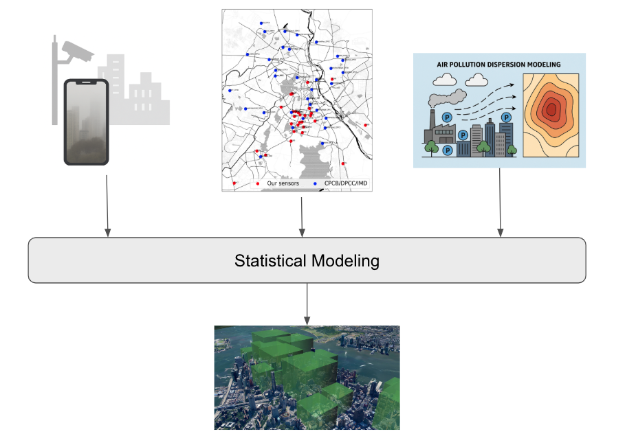
A. Scalable Urban Air Pollution Monitoring
Vision-based sensing from mobile & CCTV images
- Trained interpretable ML models estimating PM2.5 from everyday images (haze as proxy), enabling real-time, location-aware phone/CCTV sensing.
- Accuracy: MAE 44 µg/m³ → 35 µg/m³ with distributed averaging; in-interval accuracy 74%.
Interpolation over sparse sensor networks
- Built space-time interpolation (e.g., Space-Time Kriging) to infer pollution at unmonitored locations/times.
- Hotspot prediction achieves 95% precision, 88% recall with 50% simulated sensor failure.
- Mechanistic insight: companion model explains 65% of transient hotspots, highlighting policy-relevant drivers.
Unified city-scale pipeline
Combines vision estimates with sparse-sensor interpolation to yield decision-grade, city-wide pollution maps.
| Metric | Value |
|---|---|
| Image MAE → averaged | 44 µg/m³ → 35 µg/m³ |
| In-interval accuracy | 74% |
| Hotspot detection (50% sensor failure) | 95% precision / 88% recall |
| Newly revealed hotspots (residents impacted) | 189 (> 150k) |
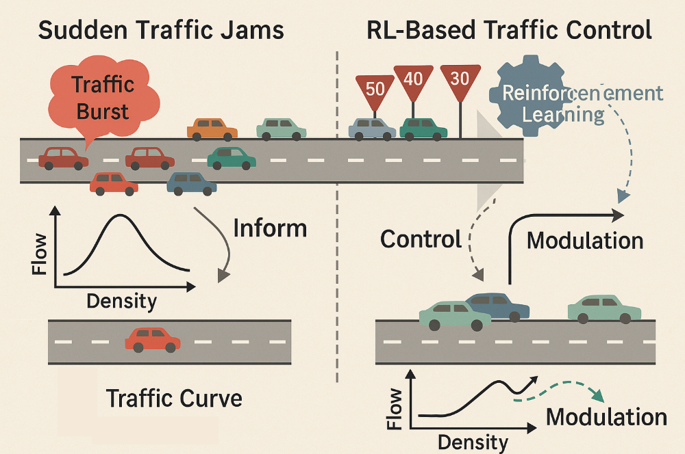
B. Understanding & Mitigating Traffic Jams
Reinforcement learning for congestion control (infrastructure-free)
- Framed freeway management as centralized, physics-informed RL to modulate target speeds and smooth flows.
- Simulation on real road networks: +5% throughput, −13% delay, −5% stops vs. baselines.
Characterizing sudden traffic jams
- Defined “sudden jams” from short, intense bursts; analyzed NYC, Nairobi, São Paulo using loop detectors and mobility data.
- Nairobi shows longer jam durations per segment, indicating management gaps.
| Throughput | Average Delay | Total Stops |
|---|---|---|
| +5% | -13% | -5% |
How do they connect?
Both projects convert low-cost signals into high-value city intelligence. Pollution mapping fuses imagery and sparse sensors into dense risk surfaces; traffic modeling turns coarse mobility data into proactive control. The thread is scalable sensing + robust modeling deployable now.
Members
- Ankit Bhardwaj, NYU.
- Rohail Asim, NYU.
Publications
Air Pollution
- A. Bhardwaj, L. Subramanian. "Towards Causal Understanding of Urban Air Pollution: Mechanistic Models under Sparse Sensing." NeurIPS 2025 Workshop on CauScien: Uncovering Causality in Science. (Link)
- A. Bhardwaj, A. Balashankar, S. Iyer, N. Soans, A. Sudarshan, R. Pande, L. Subramanian. "Comprehensive Monitoring of Air Pollution Hotspots Using Sparse Sensor Networks." ACM Journal on Computing and Sustainable Societies, 2025. (Link) (Code)
- S. R. Iyer, A. Balashankar, W. H. Aeberhard, S. Bhattacharyya, G. Rusconi, L. Jose, N. Soans, A. Sudarshan, R. Pande, L. Subramanian. "Modeling fine-grained spatio-temporal pollution maps with low-cost sensors." npj Climate and Atmospheric Science, 2022. (Link)
- A. Bhardwaj, S. Iyer, Y. Jalan, L. Subramanian. "Learning Pollution Maps from Mobile Phone Images." IJCAI 2022, AI for Good Track. (Link) (Code)
Traffic
- A. Bhardwaj, R. Asim, S. Chauhan, Y. Zaki, L. Subramanian. "Self-Regulating Cars: Automating Traffic Control in Free Flow Road Networks." AAAI Conference on Artificial Intelligence, AI for Social Impact, 2026. (Link) (Code)
- A. Bhardwaj*, S. Iyer*, S. Ramesh, J. White, L. Subramanian. "Understanding Sudden Traffic Jams: From Emergence to Impact." Development Engineering, 2023. (Link)
- S. R. Iyer, U. An, L. Subramanian. "Forecasting Sparse Traffic Congestion Patterns Using Message-Passing RNNs." ICASSP 2020. (Link)
- V. Jain, A. Sharma, L. Subramanian. "Road Traffic Congestion in the Developing World." ACM Symposium on Computing for Development, 2012. (Link)
Systems
- R. Asim, A. Bhardwaj, A. Sathiaseelan, Y. Zaki, L. Subramanian. "Modeling Economic Viability for Scalable AI Deployment in Emerging Regions." Proceedings of the 4th Workshop on Practical Adoption Challenges of ML for Systems, 2025. (Link)